Gateway to Freedom Air Show Schedule, Location & Parking
Gates Open at 9:00 a.m. Both Days
The air show demonstration is the same both days. Gates open at 9:00 a.m. with the opening ceremonies kicking off the aerial demonstrations around 11:00 a.m. The specific times for individual performers will not be released to the public because it is constantly evolving and is subject to change. The Thunderbirds start their performance around 2:30 p.m. Gates close at 5:00 p.m.
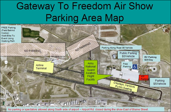
Parking Locations
All parking areas will be on the North side of the airport near the Army Aviation Support Facility and at the Rocky Mountain Emergency Services Driving Track located next to the military facilities . Parking areas can be accessed by taking Canyon Ferry Road to Bompart Lane, or from Skyway Drive off Washington Street. If arriving via Skyway Drive, continue past the airline terminal Eastbound (follow the signs).
Parking Cost
$5 per vehicle. Oversized vehicles or RV’s will be charged $20 per day. A separate area has been designated for RV’s (see map). Free parking will be available in the field East of Costco. The walking path can be utilized for walking traffic or for those wishing to ride bicycles from the parking area to the Air Show Entrance. Limited free parking is also available inside the Army Aviation Support Facility compound, and will be on a first-come, first-serve basis.
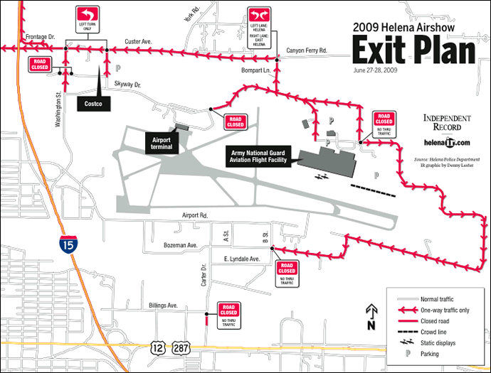
Air Show Exit Traffic Plan
In an effort to efficiently move both pedestrian and motor vehicle traffic in and out of the city, the City of Helena will be altering some traffic routes near the airport to accommodate the air show events. The detour and road closure information is listed below.
TRAFFIC WILL BE SLOW, SO EXPECT DELAYS
The Helena Police Department wants everyone to enjoy the events in Helena over the busy weekend and to reach their destinations safely. The department encourages drivers to practice patience when traveling the busy roadways and to not drink and drive.
Download an Air Show Exit Plan Map (440KB PDF) Download an Air Show Traffic Plan (2MB PDF)
Aerobatic Box Road Closures and Detours
Industrial Park
On Friday, Saturday and Sunday, the aerobatic box, where the Thunderbirds practice and perform, will need to be vacated from 1:30 p.m. to 4:00 p.m. Business owners south of the airport that are located within the box have already been contacted and advised.
Police will restrict access into the box area prior to 1:30 p.m. each day, but will then shut it down completely for all pedestrian and vehicular traffic until 4:00 p.m. No one will be allowed to stay in the aerobatic box during the 2 1/2 hour time frame.
Friday, June 26 (air show rehearsal, invitation only)
- Noon to 4:00 p.m. Road closures in Industrial Park
- Airport Road - Blaine St. to B St.
- Carter Dr. - Bozeman to Airport Rd.
- A St. - Bozeman to Airport Rd.
- B St. - Bozeman to Airport Rd.
- Bozeman - B St. to Airport Access Rd. (permit access only)
Traffic will be re-routed from Airport Rd. to Blaine St. to Bozeman Ave. to Carter Dr. during this time. (Local access only until 1:30 p.m., opens at 4:00 p.m.)
Saturday, June 27 and Sunday, June 28
- 4:30 a.m. to 4:00 p.m. Road closures in Industrial Park
- Airport Rd. - Blaine St. to B St.
- Carter Dr. - Bozeman to Airport Rd.
- A St. - Bozeman to Airport Rd.
- B St. - Bozeman to Airport Rd.
- Bozeman - B St. to Airport Access Rd. (special permit access only)
Traffic Exit Plan for immediately after the Air Show - 3:30 p.m.-6:00 p.m. Saturday and Sunday
- Carter Dr. - southbound traffic detoured at Billings Ave. over to 18th St.
- Northbound Washington St. north of Skyway, tapered to one lane-left turn only at Custer.
- Kelleher - southbound closed from Custer to Cromwell Dixon. Cromwell Dixon - Washington to Costco entrance - (access to Costco off Washington or via Skyway to Kelleher to Cromwell Dixon).
- Cromwell Dixon (east of Washington St.) - no access onto Washington St.
- Skyway - east of Main Terminal closed to through traffic.
- Skyway - westbound lane closed from Bompart to Main Terminal.
- Bompart Ln. - closed to southbound traffic. Both lanes will be used one-way, northbound traffic to Canyon Ferry Dr. Left lane will be routed towards Helena, right lane will be routed towards Wylie Dr.
- Custer/Canyon Ferry Dr. - eastbound lane closed from Sanders St. to Bompart Ln. Westbound lane will be open.
- Frontage Rd. - southbound lane closed from Stable Rd. to Custer.
- York Rd./Canyon Ferry Dr. - no left turn onto Canyon Ferry Dr.
Westbound traffic on Custer Ave. will be heavy and may back up over the Custer Overpass. Officers will alternate sending westbound traffic north on Frontage Rd. to reduce congestion. Traffic routed north on Frontage Rd. can go west on Sierra, and south on Montana to get back to Helena.
** Times and performances subject to change **